Dimapur, June 3 (EMN): The Governor of Nagaland on Friday notified the inter-district boundary between Peren and Chümoukedima (erstwhile Dimapur) districts, more than five months after the state Cabinet decided to make the latter a separate administrative unit along with Tseminyu and Niuland in December last year.
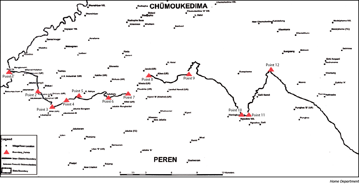
The boundary demarcation between the two districts was done in accordance with the recommendations of the Cabinet Sub-Committee report. However, the decision for the stretch from point 7 to 8 (refer map) of the recommended boundary, which is touching the areas covered by the three unrecognised villages -- Vihoto, Phushito and Kiyevi ‘B’/ Khehoi -- will be taken up later, said the notification.
“The notified inter- district boundary is solely for administrative convenience and does not reflect the traditional boundary in any manner,” it stated, adding that the notice was issued in pursuance of the decision of the Cabinet conveyed on May 26.
According to the annexure provided by the Home Commissioner, Abhijit Sinha, the inter-district boundary between Peren and Chümoukedima districts shall be as under:
From Point-1, as shown in the map, the boundary line shall move straight towards the Old Forest Rest House in the North Direction, which is approximately 300 metres away from Point-1. Leaving the Old Forest Rest House, the line shall follow the approach road the East direction till it reaches the ridge. From this ridge and leaving the approach road the boundary line shall move towards Daniel Village, but before reaching the Village, the line again shall proceed further to meet the hilltop in the East direction. From this Hilltop the line shall move in the South East direction crossing the confluence of two unmanned stream lakes which shall continue moving further straight to meet another confluence of two streamlets. Thereafter, the boundary line shall move upstream south ward till it meets the approach road between Jalukiezangdi and Shikavi villages on the lowest point (Saddles). From here the line shall move downwards in the Southern direction to meet R. Ketsiangkeiuki (Laidiling Disa) to wind up to Point 2.
From Point-2, as shown in the map, the boundary line shall move upstream of R. Ketsiangkeiuki for approximately 1 Km east wards Pokhaho village. Here the boundary line shall follow a small stream in the South East direction leaving the R. Ketsiangkeiuki to reach the top of the hill. Once again, the boundary line shall move downhill to meet a small stream till it ends up at R.N/ Disa (the line so followed here is South of Pokhaho village).
From Point-3, the boundary line shall follow R.N/Disa in the North East direction till it reaches the Old British/ Forest Road marked Point-4, which is approximately 2 or 3 km from the North of Jalukie Sangtam.
From Point 4, the boundary line shall follow a Stream in the North East direction which is tributary to Ballu Nallah/ H. Disa to meet Point No. 5.
From Point 5, as the Line follows R. Disa upstream in the South East direction, it shall extend up to the top of the Hillock (Aluto) South of Xekiyi village at Point-6.
From Point 6, leaving the Hilltop Aluto, the boundary line shall move along the Hill Range in the North East direction up to R. Tsuhaureu. The boundary line shall continue upstream in the South direction for approximately 800 metre. Leaving R. Tsuhaureu here the boundary shall go up to the Approach Road that leads to Shikuto village. The Boundary Line shall follow this road but towards Zutovi Village for about 700 metre to meet a small stream. It shall continue to follow this downstream towards East and meet R. Nkwareu (Langlong).
From point 7 to 8 i.e., touching the areas covered by the three unrecognised villages of Vihoto, Phushito and Kiyevi 'B'/ Khehoi, a decision shall be taken at a later date.
From Point 9 i.e., confluence of R. Khova and R. Ramgareu (Thegwukeru), the boundary line shall follow R. Ramgereu up to Etupelezie Lake which shall be considered as Point-10.
From Point 10, the boundary line shall cut straight for about 500 metre (approx.) and meet Point 11.
From Point 11, it shall follow downstream R. Ngaireu/ Khakheru till the confluence with Chathe River which shall be considered as Point 12.
From Point 12, the Boundary line shall go upstream from Chathe River till the confluence with R. Miannuonuru/ Nebomreu and proceed upstream along R. Miannuonuru/ Nebomreu till its source joining Kohima District Jurisdiction.